- HOME
- PRODUCTS & SERVICES
GIS/GPS in Smart Cities/Transport METRIS — Big Data in Metro Transportation METRIS LiveQ: Real-time Truck Queues METRIS — Port Performance METRIS — GPS Tracking METRIS — Transport Planning Advanced GIS Analytics/Algorithms Transport Research Error Modeling Conflation GIS in Retail CLEO — Location Optimization Trade Areas Gravity Models Location-Allocation Models Enterprise GIS Strategic plan & cost-benefit analysis GIS Data Modeling GIS in Security Critical Infrastructure Protection Emergency Preparedness
- RESOURCES
News & Commentary METRIS News & Press Reports Light Technical Geography 80-20 (nuggets for adults) Geography Kids' Hangout Technical GIS Publications METRIS Publications Associated projects NCRST VITAL
- ABOUT
GPS Operations: Positioning, Plotting and Placing
Val Noronha | The Geography 80-20 collection
There are broadly at least three ways we can think of location: (a) a point on the ground, (b) a point on a map, and (c) coordinates: latitude-longitude or UTM. For limited sets of locations, there are other descriptive methods such as street addresses and landmarks but we won't cover them here.
It follows that the basic challenges are in translating between field location, maps and coordinates:
- Locating: This is a less formal term than the others on the list. It means to discover the position of something, which could mean finding it in the field, reading a GPS coordinate, or finding it on a map.
- Positioning: Given a spot on the earth, determine its coordinates;
- Plotting: Given coordinates, identify/mark their location on a map;
- Placing: Given coordinates, find the corresponding point in the field.
- Orienting: In the field, observe landmarks and compare with a map to determine where you are. If you fail to achieve this, you're officially “lost.”
All of these tasks are quite easy today, thanks to GPS and web-based maps. Here we're going to talk about some of the non-obvious difficulties working with them. (If you're wondering about the not-very-self-evident nomenclature, standardizing the terms positioning and placing is something that navigators and transport engineers like to do; geographers not so much.)
Positioning
Positioning is easy with GPS. Stand at the spot, turn on the GPS and record the lat-long. Bearing in mind the inherent inaccuracy of GPS, allow time to pick up several readings, and average them.
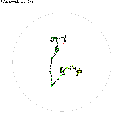
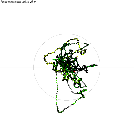
How many is several? GPS error tends to be persistent, which means that it stays roughly constant over a period of time (minutes). The reading walks around a zone say 3 meters southwest of the true position for some minutes, then makes a dash to 4 meters northeast for a few minutes, then something else, all seemingly random, but usually within a circle of uncertainty around the true location. You can't place your faith in any single reading, even say 100 readings over a couple of minutes. Over an hour, the readings are not evenly distributed within the circle of uncertainty, but you can average them. Depending on your need for accuracy and tolerance of error, you have to stay put for at least 15-30 minutes to get a valid average.
|
|
|
| GPS readings taken over a
couple of minutes, centered on the average. The oldest
readings are in yellow, followed by green and black,
with the current point in red. Circle radius: 20 m |
GPS readings taken over an
hour. Circle radius: 25 m. |
Differential GPS (DGPS) gets rid of much of this error. DGPS equipment can cost up to $30,000 for millimeter-level positioning. For 3-5 m accuracy (a traffic lane) which suffices for most of us, there's the Wide Area Augmentation Service (WAAS) in the U.S., or more generically, Satellite Based Augmentation Systems (SBAS). The service costs nothing and is commonly pre-installed on consumer equipment.
Plotting
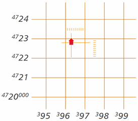
Translating coordinates to a map location is a matter of interpolating on a reference grid. On a computer it's a straightforward task: type in the coordinates and a friendly application does the hard work. Example
But when you're out in the wilds with a hardcopy map, you have to figure out exactly where your GPS reading falls on the map. If you have a ruler, calculator, and several minutes to spare, that's fine. If not, you want to use the printed grid. Modern topographic maps usually overlay a dense UTM grid at 1 km spacing, which allow you to interpolate your location with an accuracy of about 100m. But this means you need to know your coordinates in UTM rather than lat-long. In the illustration, the UTM coordinates of the cabin are (396300, 4722800). More on UTM
Dedicated GPS units have a UTM display option, but multi-purpose devices (e.g. car navigation systems and smartphones) typically do not. Make sure you're carrying the right GPS equipment and maps. A useful smartphone app is Handy GPS, available free for Android and iOS.
USGS digital topos (1:24,000, 7.5 minute) come in two flavors: older maps are scans (bitmaps), newer maps are layered vector PDFs with less detail (e.g. campgrounds and spot elevations are less likely to appear). But the new edition has the UTM overlay, which is a big help in position mapping in the field. The layered feature means that you can query coordinates in Acrobat. The topo maps at CalTopo (an excellent online topo map resource) generally offer the older maps: better detail but no grid.
Placing
Again, this is the problem of going to a field location that corresponds to coordinates (“placing” a marker in the field, if you like to think about it that way). There are three possible approaches:
- Instrument approach. Enter the coordinates into a nav system
and instruct it to guide you there with direction arrows and
distances. Some handheld dedicated GPS units will do this; but
because their interfaces are limited (there's typically no numeric
keypad), they can direct you only to points already in memory.
- Map approach. Plot the point on a map/photo, and based on
the landmarks common to the map and ground, find your way
there. In a city, maps show every street, and it's relatively
easy to navigate. In the wilds, location cues are subtle and
even the best maps can be inaccurate and inadequate if you're
trying to place a point at the level of a few meters.
- Diehard approach. Find your way to the spot using the GPS readout exclusively. This is not difficult if you know the key secrets of working with lat-long and translating it to distance on the ground. Take your eye off the display sometimes and watch for cliffs, poison ivy, and rattlesnakes
Again, GPS error can be disconcerting: you've just homed in on the right coordinates and mysteriously the reading changes by several meters. Always bear in mind the specs and limits of your technology.
Placing is the technical basis of geo-caching, or at least the retrieval
half of it — positioning is the first half. The trick in urban
geo-caching is not technical; it's respecting property and
dealing with angry neighbors and dogs. This is where the map
approach scores over the diehard approach.

Tweet this URL
© Digital Geographic Research Corporation Contact us