Strategic Retail Location
Trade Areas
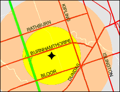
The notion of a Trade Area is appealing and
popular. It
is easily visualized
as a circle of say 5 km radius around a store—the exact radius is
based
on experience or analysis. Given appropriate demographic data,
GIS
can easily calculate the size of the market, or profile the
socio-economic
composition of the area. This is a quick and effective solution,
at least superficially.
 The
Trade Area was a useful concept in the days when market analysis was
limited
to rough estimates and mental arithmetic. But in a computing
context,
where we compare locations based on quantitative performance estimates,
a number of difficult questions arise. The
Trade Area was a useful concept in the days when market analysis was
limited
to rough estimates and mental arithmetic. But in a computing
context,
where we compare locations based on quantitative performance estimates,
a number of difficult questions arise.
- It assumes that people travel in straight
lines. This
conceptual error alone overestimates the market by nearly 60%. It's
possible
to get around this by calibration.
- Constructing a circle,
we imply that all people residing within that radius are our customers,
and that nobody outside that radius shops at our store. This is
of
course unrealistic. It ignores traffic and the effect of nearby
attractions.
- It assumes away the competition.
- It assumes that demand is evenly distributed.
The truth is that residential density varies considerably.
Some analysts try to skirt these problems by
counting only a
portion of
the population within the circle, or considering non-circular trade
areas
(“amoebas”), or primary and secondary trade areas, and a special
derivative,
the Thiessen polygon. Arbitrary ratios are applied to account for
competition and distant traffic.
 All these attempts are subject to the
ultimate
criticism that a trade area is in reality fuzzy and dynamic; it is a
construct
in the mind of the retail analyst, not the shopper. Trying to draw a
boundary
around it is artificial and arbitrary. The treatment of competitive
effects is
entirely
inadequate. All these attempts are subject to the
ultimate
criticism that a trade area is in reality fuzzy and dynamic; it is a
construct
in the mind of the retail analyst, not the shopper. Trying to draw a
boundary
around it is artificial and arbitrary. The treatment of competitive
effects is
entirely
inadequate.
In today's mobile society, shopping behaviour
and
store choice
are subjective
choice processes that depend on a range of factors such as advertising,
ambience, complementary shopping opportunities and daytime traffic, as
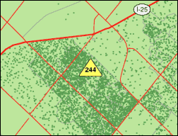
much as on proximity to one's place of work or residence. Dot density
maps (right) or ideally customer spotting are far better suited to
understanding retail behavior. A class
of models known as Gravity Models (more properly, Spatial Interaction
Models)
is used to forecast attendance.
|